In case this can help any other campaign groups, I shall leave these points in place as it provides a useful timeline and explanation. Please note, council portals may differ.
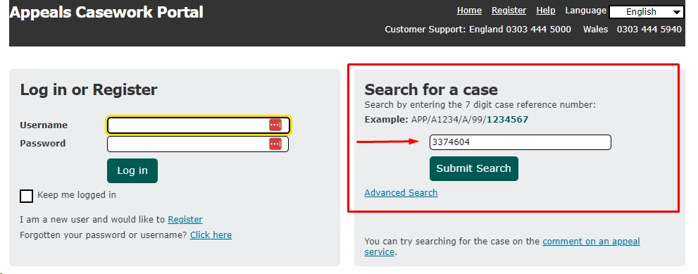
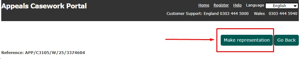
Helpful hints on getting to the Appeal Portal page (useful sentences to use in your comments below this section).
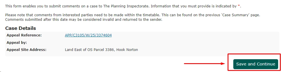
Then click “Save and Continue” (to get to the page with the Form):
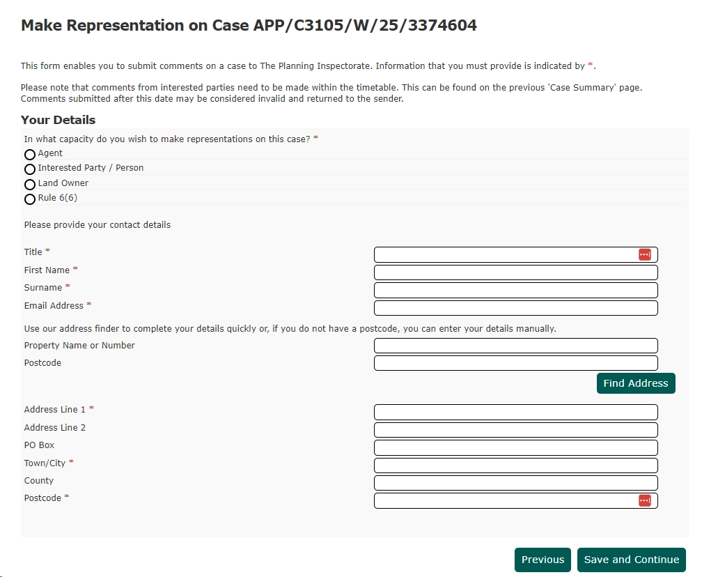
This then takes you into the Form itself where you enter your details and can leave your comment:
I know this is a big ask, BUT if we can ask you for another 5 minutes of your time we would be so grateful.
Please take the time to Object to this Appeal. You don’t need to be a planning expert, you just need to say why you care.
Make sure you say that you object to the Planning Application right up front then you can go on to say why.
First up is to say that “Nothing Has Changed” since last time the Inspectorate turned it down in May 2024. This application is worse than the previous one because there are more houses so more downside and nothing is better about it.
Because of the type of application the Inspector is limited in what they can look at, so we have to focus. It is all about the following three points:
Location – why this is a bad place to build, it is outside the built up village limits, location excluded in the Neighbourhood Plan, traffic levels,
Land Use – destroying agricultural land, overlooking the Conservation Area, the importance of the footpath and the space around it to the village, nature and
Amount of Development – not NIMBYs, plenty of other development in the village but not here. Adds nothing to affordable housing in the village but destroys an important green space.
There are some useful sentences to help below if you want to use them as a model.
Please add a few personal words — such as how long you have lived here, how you use the lane or fields, or why you value the countryside. That will make your comment count as an individual representation.
Wrap it up with a polite request to the Inspector to follow the lead of the previous Inspector and turn the Appeal down.
Location sentences :
This field should not be built on. It is outside the envelope and built up limits of the the village. It is south of the village, and the village decided in the existing Neighbourhood Plan that this was one of the places that should not be developed. Burycroft Lane is too narrow and already too busy. There are walkers, horses, cyclists all using the lane. Further traffic from up to 5 more houses will just make it more unsafe. This proposed development is in the fields outside the village. The access is in a dangerous location. The footpath and its setting within the ancient pasture is important to the surrounding green space of one of the few Ironstone Villages. It’s on the rural edge of the village with no pavements or lighting.
Land Use sentences:
This is ancient pasture, home to a wide variety of wildlife. The destruction of the hedgeline will remove a natural corridor along the top of the field. The valley is a key element of the green setting of the village and the Conservation area, which would be lost if the top of the field was to become housing. There are protected species in the area and using the field, such as Great Crested Newts, barn owls, otters and bats, all of which would be disturbed by the housing development and ongoing human occupation. This is open land with landscape and ecological value, crossed by a public footpath, and is not appropriate for housing. This is open countryside with a valued footpath, not suitable for housing. The land use is wrong — it’s open countryside, not a housing site.
Amount of Development :
This site is not like the other big developments around the village. They are north of the village, in areas which were envisaged by the Neighbourhood Plan. Five houses will not make a significant contribution to the need for affordable housing. The long term, permanent loss of the field and its heritage is far greater than any gain in employment during the building of the housing. Squashing up to five houses on the edge of a field outside the village does nothing for the need for accessible affordable housing but will lose the village this key green space forever. The previous appeal for one house was dismissed, and increasing this to 3–5 homes would only increase the harm. The Planning Inspector already refused this site in May 2024, and nothing has changed since. The appeal should be dismissed.
Their appeal documents can be found here on the Cherwell Planning website here.
A massive “Thank you” to everyone who submitted a letter, email or comment against this new application in July.
OBJECTIONS NEED TO BE RECEIVED BY 9TH JULY 2025 a very limited time frame.
Please focus on the following main three points in your objection (more details below):
Location – Is the site suitable for housing? Land Use – Is housing (or housing-led development) appropriate here? Amount of Development – Is the proposed number of dwellings acceptable?
Looking through the current application submission it seems to me the main difference is a new hook that this is more than one dwelling and therefore it would result in greater public benefit in respect of housing delivery at a time the Council has a shortage in its housing supply. However, we shouldn’t don’t buy that argument. Nor should the Council. Para 29 of the previous appeal Inspecter’s letter sets out the context here. On that point I would say that 3-5 dwellings at this location would result in substantially greater harm than the previous scheme for a single dwelling.
Notwithstanding the fact the housing land supply has become worse, as noted in Para 29 of the Inspector’s letter the exercise required here is consideration on whether the adverse impacts of granting planning permission would significantly and demonstrably outweigh the benefits when assessed against the policies in the Framework taken as a whole.
The previous appeal Insector’s considerations on the suitability of the location for new housing are set within Paras 14-19 and 24-25 of her letter. All points set within those paragraphs remain relevant. Indeed, the current application submission attempts to provide no evidence to challenge those conclusions. Nor, importantly, does it seek to make a case that the environmental circumstances of the locality have changed.
As noted earlier, the Inspector found significant conflict with the development plan, the harm arising from encroachment into the countryside and harm resulting from the site’s somewhat
compromised access to services and facilities. Those matters remain unchanged. If that was the resultant harm resulting from a single dwelling, that degree of harm would be significantly intensified by 3-5 dwellings. As such, I would say the previous Inspector’s conclusion remains relevant and valid in the assessment of the current proposal.
What is Permission in Principle (PiP)?
PiP is a two-stage process used mainly for small housing developments (typically up to 9 homes on less than 1 hectare of land). It separates the principle of development (i.e. whether housing is allowed on the site) from the technical details (such as design, access, drainage, etc.), which come later.
✅ What is assessed at the PiP stage?
At this stage, the local planning authority (LPA) can only consider three main issues:
Location – Is the site suitable for housing?
Land Use – Is housing (or housing-led development) appropriate here?
Amount of Development – Is the proposed number of dwellings acceptable?
No other matters can legally be considered at this stage, including:
Traffic and parking
Impact on neighbours
Design, layout or appearance
Ecology, trees, and drainage
Access or infrastructure
🚫 What you can’t object on at the PiP stage
Overlooking or loss of privacy
Traffic/parking concerns
Building design/height
Noise or construction disruption
Detailed ecological impacts
These issues will be dealt with later if the applicant submits a Technical Details Consent (TDC) application.
🗣️ How to object effectively at the PiP stage
You need to focus objections on the three allowable criteria. Here are examples:
1. Location
The site is not in a sustainable location (e.g., far from public transport, shops, schools).
The development would harm the character of the countryside/village.
The location conflicts with the Local Plan or Neighbourhood Plan policies.
2. Land Use
If the land is undeveloped / greenfield but not designated: “The proposed use of this undeveloped greenfield site for residential development is inappropriate, as the land has not previously been identified for housing and lies outside the established village envelope.”
If the site contributes to the rural character: “The site’s current use and character contribute to the rural identity and open setting of the village, and its development for housing would result in an unjustified change of land use.”
If the site is inconsistent with the local plan: “The proposed residential use conflicts with the intended land use in the Local Plan/Neighbourhood Plan, which does not allocate this site for development and prioritises brownfield or infill sites.”
If the site is poorly suited for housing due to its surroundings: “The surrounding land uses — such as agricultural, commercial, or open countryside — make the site unsuitable for residential development in terms of compatibility and long-term sustainability.”
It’s near heritage assets.
3. Amount of Development
The number of houses proposed is excessive for the size or context of the site.
The density is out of character with surrounding development.
📝 Next Steps
Check the Local Plan and Neighbourhood Plan policies relevant to the site.
Submit your objection in writing before the consultation deadline.
Focus only on location, land use, and amount of development.
If PiP is granted, you can object in much more detail at the Technical Details stage — including highways, drainage, appearance, etc.
On the 7th May 2024, the Planning Inspectorate dismissed the appeal from the Applicant for the original development of a single dwelling.
A hearing was convened on 6th February 2024 with the Planning Inspector and the decision was announced on the 7th May 2024.
A massive “Thank you” to everyone who submitted a letter, email or comment against this development.
Story so far…
A planning application was originally submitted for the Sledging Field to the north side of Croft’s Lane/Burycroft Road in Hook Norton, diagonally opposite the allotments.
Application number is 22/03626/F with Cherwell Council.
There was then a hearing on 6th February 2024 with the Planning Inspectorate and the final decision to dismiss the appeal was announced on the 7th May 2024.
For archive reasons we will leave these points below in place:
This is a planning application that runs against planning policy for the conservation & enhancement of the local rural character; scale & massing conflict with local context; significant harm to local landscape character and views.
With the development of Hook Norton at saturation point and with the possible development of 75 new houses around the cricket pitch and surgery, this is single development of a private house in a green field site with 5 bedrooms, incorporating a cinema and gym. The Public footpath will have to be moved around the site to allow for the development.
The field is noted in the Neighbourhood Plan as not suitable for development. Page 18 of the plan states: “Similarly, land between the old railway and Park Hill/Beanacre was not considered suitable, nor was development to the south of the village (off the Chipping Norton Road, Swerford Road, Burycroft Road/Crofts Lane or the fields either side of the stream).“
Initial points that could be used for an objection (further focus points below):
1. The proposed site is outside the established village boundary and therefore is contrary to the following policies – Cherwell local plan 2031: Policy H18 New Dwellings in the Countryside Policy ESD 13: Local Landscape Protection and Enhancement Policy ESD10: Protection and Enhancement of Biodiversity and the Natural Environment Policy ESD 11: Conservation Target Areas. ESD 13 Local Landscape Protection and Enhancement
2. The proposal will result in a significant negative impact on an historic Footpath which would be detrimental to the ability to traverse the footpath in a a safe and convenient way.
3.The scheme will result in a significant negative impact upon the landscape, being highly visible from a public foot path and several adjacent vantage points.
4.The scheme will adversely impact the setting of the Conservation Area and St Peters Church from several public vantage points.
Further points are:
Conflict with the Development Plan – Hook Norton Neighbourhood Plan and Cherwell Local Plan 2011-2031 Part 1:
Adverse effect upon the setting of the Hook Norton Conservation Area, especially the “green valley” and key views (click the images below to view larger versions of images):
Diversion of the well-used public footpath and harm to amenities of users of the footpath
Precedent for further unsuitable development along Burycroft Road, which is unsuitable for further traffic
Further focus points:
This is not a development area:
The proposed site is in open countryside and would represent an extension to the village boundary. 1881 maps are irrelevant – the village boundary has been identified as after the last three bungalows on the north side of Burycroft Road, and the other only includes what was Gilden Farm, as it was a redundant agricultural building.
There is no precedent for green field development in the South of the village. The only properties developed have been on the site of existing houses or buildings (Gilden Farm now England Farm and barn below Bean Acre Cottage are both on the footprints of older houses and in their domestic areas).
The field has been part of grazing plans for local farmers for years and is a viable agricultural resource. There are sheep now, but there have been ponies and cattle at various stages over the years. The small holders have been successfully raising pigs in a corner of it for a number of years. It is not waste land.
This application is contrary to the Hook Norton neighbourhood plan which was adopted by Cherwell District Council and is current policy. Key matters that are specifically relevant to this application are:
The plan makes it clear that expansion of the village boundary beyond existing settlement limits is not acceptable to residents
Land to the South of the village generally, and specifically land either side of Burycroft Road and Crofts Lane are highlighted as locations unsuitable for development. It has been defined as ancient pasture land and should remain unploughed and definitely not built upon.
It is also outside the areas for development in the current draft Cherwell plan.
The addition of one property does not address housing need in the village in any significant way, as is acknowledged in the application.
The thin end of the wedge. If an exception to all the above is made for a single house, why not six? Why not all the way along Crofts Lane? Once the principle is established that it is okay to build on ancient pasture south of the village, then the next stage is for one to become more. It is a frequently used route for developers to increase the size of a development.
Conservation area. While this site is outside the Conservation Area – just – it is visible from the Conservation Area and therefore must meet a number of criteria. To quote from a letter from Cherwell received when we were enquiring about a change of use in 2008 for part of the field “the land in question is characterised as “green fields” in which land use is limited to meadowland, grazed pasture and river valley pasture and woodland and which is crossed by a series of footpaths. This land affords extensive and attractive views into and out of the village and provides a valuable countryside setting to the village. These proposals will result in the loss of river valley pastureland and its incorporation into domestic curtilage. This can have quite dramatic consequences in terms of character with a change in character emphasised by domestic features and paraphernalia ….. as well as features such as cut lawns, rockeries ….. the existing green fields character will be undermined to an unacceptable degree. As the land is crossed by a public footpath this change in character will be particularly visible. ” Simply on this basis this application should be refused.
The footpath.
The route. The new route for the path will lead through low lying part of the field that gets very muddy and becomes flooded most winters. When it is flooded or slippery it will become dangerous. That is why the traditional and mapped routes run higher up the field where the footing is safer.
As the proposed path runs down from Burycroft Road to the stream it will be following the steepest gradient, which will become muddy, slippery and unsafe after rain. Indeed, it has the potential to become a stream in bad weather.
The open views of the conservation area. The path is to be edged by a ‘native hedge’ down to the stream. The application is silent on the proposed height of the hedge, not least because it will inevitably be to allowed to grow high and thick to protect the privacy of the house. This will block the light from the footpath, making it dark and wet in almost all weathers and remove all views of the Conservation Area from the path. If it is to be built, it would be better if the planners were to mandate a field edge wall, made of local materials, to the height of say 1metre with the local stones on edge as a topping as the boundary. This would be consistent with the described meadow planting, maintain the open views from the footpath, which will also keep it drier. Of course it would be better still if nothing was built at all.
Creating a copse of 5 Scots Pine (Pinus sylvestris), 5 flowering cherries and 5 oak by the entrance to the footpath will further darken the access (see drawing D101A). This is excess planting of over large species of trees. The hedge is sufficient, if there has to be a hedge.
Impact on nature
Removal of trees. The tree survey provided indicated some drastic changes to the tree line by the lane are proposed. One mature tree is to be removed completely and 5 more removed and potentially replaced. This changes the nature of the roadside from a look of open countryside to one of residential frontage and exposes the property to the road. Even assuming that these trees were replaced, any such replacements would take a very long time to recreate the same effect, probably over 20 years.
The hedge is in poor shape, having been neglected for years. The drastic removal of trees and extensive pruning proposed by tree plan will adversely affect all the local species of birds, the squirrels and the hedgerow mammals. The necessary hedgerow management should be undertaken in a phased way over several years, even if the development of the field does not take place.
There are kites, buzzards, tawny owls who all nest in the high quality woodland beyond the field, and would be disturbed by building activity and the house.
Forcing the footpath closer to the stream will also adversely affect the stream wildlife. Kingfishers and herons are often seen there, otter spraint has been found further upstream so it is likely that they occasionally visit. Foxes, muntjac etc all use it as a source of water. The ducks haven’t been seen since the pond downstream was removed. The footpath needs to be kept clear of the flat area by the stream.
Protected species. The barn owl hunts over the field, the ravens visit. Pipistrelle bats hunt over it and will be affected by loss of habitat and light pollution, and some roost behind the bird boxes on local houses so there must be other populations around. Great Crested and palmate newts have been seen, although none since the pond (referenced as still there on page 23 of the Ecological survey) was filled in. There are white clawed crayfish in the.
It is to be noted that there are no nature bodies included in the statutory consultees. There are only the villagers to care for nature in the face of these destructive plans.
Local issues
A key part of the local heritage of the village would be destroyed. Generations of children have grown up sledging down the slopes in that field.
Access is problematical and potentially dangerous. Burycroft Road is very narrow at the point of access proposed, has no pavement and is unrestricted in speed. Passing other vehicles on the road is very difficult; in fact impossible for much of its length. It is well used by pedestrian traffic, dog walkers and joggers and further traffic joining at a blind corner should not be encouraged. The building phase in particular would be very dangerous.
Don’t be beguiled by the planting plans or house design. It is about stopping any development in an ancient green field site. There should be NO development on this site, full stop.
All the stuff about meadow planting and native trees in the garden. The planners cannot mandate this or police it. The eventual owners will be doing the planting and the developers can’t dictate to whoever buys the house (or the plot with planning permission). They can put orange begonias and pink plastic flamingos if they like once they are in.
A bench at the corner of the footpath. So? Is that the community return?
There is mention of England Farm and its building materials which is irrelevant. Like it or not, it was built on a previously occupied domestic site.
What is being proposed is destruction of a green field and needs to be the focus.